


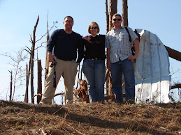
Dew and the gang are just east of this area. Looking at a wall cloud...
Top image is Level 3 data via Gibson Ridge. Middle and bottom pictures are via GR2-AE. The legend for the bottom image: upper left is Base Reflectivity 0.5deg (Radar site not far to NW), upper right is Storm-relative Velocity 0.5deg, bottom left is estimated hail size, bottom right is NROT, a new rotational product specific to GR-2AE. The icons are hail size indicators. GR-2AE does not contain storm path data, as it pulls Level 2 radar info.
Gregg Stumpf, Charles Edwards, and Tony Laubach are in the general area, as well.


.JPG)


No comments:
Post a Comment